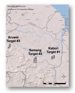
Overview of GlobalMin Ventures’ Guyana Platinum Projects
The Guyana Platinum Project (GPP), an area of mainly greenstones, mafic and ultramafic intrusions, and granites is approximately 128,000 acres containing three discrete PGM targets. Each is a PGM target for its own unique reasons: Target 1 is the Kaburi anorthosite which shows a linear Pt anomaly over a distance of at least four miles in soils and biogeochem samples, interpreted as reflecting a PGM reef in underlying bedrock because of similarities with the Merensky Reef in the Bushveld of South Africa and the J-M Reef in the Stillwater of Montana; Target 2 is the Semang dike, a gabbroic dike approximately 25 miles long and perhaps a mile wide, with zones of Pt-Pd anomalies in soils and bedrock (up to 203 ppb Pt); Target 3 is at Aruwai, a reach of the Mazaruni River approximately one mile long near Venezuela that may contain as much as 100,000 ounces of Pt and 50,000 ounces of Pd in river sediments. It is the bedrock source of this profound Pt-Pd anomaly that is the focus of exploration efforts at Aruwai.
Guyana Property Location and Description
The Guyana PGM project was secured by a Permission for Geological and Geophysical Survey (PGGS) from the Guyana Government. This original 4.4 million acre concession is now being converted into 10 Prospecting Licenses (PL). Each PL can be up to 12,800 acres in size and is good for 3 years, with the possibility of two, one-year extensions, subsequently convertible into mining licenses of 20 years or more. The locations of the PLs are shown on the topographic relief map to the right.
Our Three PGM Targets
Target 1: Kaburi Anorthosite
This property is the Kaburi anorthosite, a PGM exploration target because of similarities to the Merensky Reef in the Bushveld intrusion of South Africa and the J-M Reef in the Stillwater intrusion in Montana, USA. Target 1 shows a linear Pt anomaly over a distance of at least four miles in soils and biogeochem samples, interpreted as reflecting a PGM reef in  underlying bedrock. The Kaburi location is accessible by dirt road from the frontier town of Bartica at the confluence of the Essequibo, Cuyuni, and Mazaruni Rivers, as well as by boat up the Mazaruni and Kaburi Rivers. There are no facilities or towns in the area.
Target 2: Semang Dike
This target is the Semang dike, a gabbroic dike approximately 25 miles long and possibly a mile wide, with zones of Pt-Pd and related-element anomalies in soils and bedrock (up to 203 ppb Pt in initial samples). It is located at the Semang dike, near the village of Semang on the Mazaruni River and is accessible by boat only. A new road is being built from Issano on the Mazaruni to the Semang River, which would give road access from Bartica to the Semang dike in the future.
Target 3: Aruwai
This target area covers an airmag anomaly coincident with PGM-rich alluvial sediments. It is located at Aruwai, a mining camp on the Mazaruni River above the large Peaima and Aruwai Falls. Access is by boat up the Mazaruni River to Pott Falls landing and then by 4×4 along a dirt road to Aruwai. Additional access is by small airplane into a dirt airstrip at Aruwai.
Infrastructure and Climate
Infrastructure is minimal within the PGM concession areas, and no commercial power sources are currently available at any of the three targets, although a small hydroelectric plant could be installed on the Mazaruni River near Aruwai. The climate is tropical, being located at about 6 degrees north latitude, with annual temperatures of 80-90 degrees Fahrenheit and having two wet seasons, in June-July and December-January.


