Target 3: Aruwai Project by GlobalMin Ventures
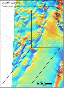
Mazaruni River sediments at Aruwai contain the highest proportion of PGMs to gold of any sediments yet sampled in the many rivers of Guyana. Aruwai is approximately 20-30 miles from the Venezuelan border, close to the large, platiniferous, layered mafic intrusion in Venezuela called Mochila. Mochila is Pre-transamazonian Technothermal Event at 2.0 Ga, and is considered to be 2.1-2.2 Ga in age. The Mazaruni River in the vicinity of Aruwai can be shown to be eroding similar older mafic rocks, which may be the source of PGMs in river sediments there. Circular and linear airmag anomalies appear to be coincident with the greatest abundance of PGMs in Mazaruni alluvial sediments, estimated at up to 100,000 ounces of Pt and 50,000 ounces of Pd.
Interpretation and Conclusions of the Sampling Program
Target 3 at Aruwai remains an exciting target because of the large amounts of Pt-Pd-Rh that are present in the Mazaruni River sediments there. The river is eroding older 2.1-2.2 Ga mafic rocks similar to the Mochila layered mafic intrusion in the nearby Venezuelan portion of the Guiana Shield. There is potential for the discovery of significant PGM mineralization at Aruwai simply by virtue of the massive alluvial anomaly that may be related to an airmag anomaly approximately two miles in diameter.
Our Exploration Plan
Target 3 is an area of the Mazaruni River and adjacent terrain near Aruwai. The river sediments near Aruwai have been estimated to contain up to 100,000 ounces of platinum and 50,000 ounces of palladium, an extraordinary amount of these very rare metals. A large portion of the platinum-group minerals in these sediments is dominated by Pt-Pd-Sn minerals such as rustenburgite and atokite, and generally exhibit euhedral crystal forms suggesting short transport distances by the river.
Little greenstone or mafic bedrock is exposed along the margins of the river, the bedrock being covered by a blanket of overbank alluvial sediments, making ground geochemistry ineffective. GlobalMin plans a high-resolution ground geophysical survey of the area, followed by drilling into bedrock along the river margins. Holes will initially be drilled to 200-500 feet to penetrate the overbank sediments that are generally less than 50 feet thick and to assess the geology and mineralization of the 2.1-2.2 billion-year-old bedrock that the Mazaruni River is eroding in this area.
.


